Welcome,
Guest! Login
Login
0 Items
$0.00
$0.00


Login to enter your own
review of this item.
 The Historical Archive is dedicated to creating a large, robust library of DVD and CD based products covering a wide range of significant and interesting historical events and cultural moments through film, photos, audios, maps and other documents. This growing collection of unique, special interest DVDs and CDs covers the full range of significant events that have shaped our culture, entertainment values and history.
Center total is the Seller's overall score, averaged from each active component:
|
Atomic Mall Feedback: Imported Feedback: Order Fulfillment Rate: |
100.0 99.8 100 | |
| Trophies Earned | ||
|
|

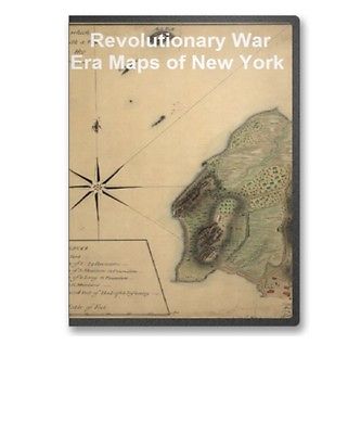
This CD contains 84 rare antique maps and descriptive pages representing fascinating details about New York and its vicinity during the Revolutionary War in MrSid format. T his format allows you to see the entire map on your computer screen or drill down to see the smallest details. The original maps are often quite large, as much as 36" long or larger and quite detailed. With the MrSID software, you can manipulate the map to print the entire map in great detail or zoom into a portion of the map in full detail for viewing or printing. You could even bring the images to a local print shop to have the maps reprinted in their full size. (MrSID software is included on the CD.)
To give you a sample of the detail you can expect in these maps, here is an example based on a panoramic map of Washington, DC.
The table below shows the and a small image of each map on this incredible history CD.
A survey of Lake Champlain including Crown Point and St. Iohn's on which is fixed the line of forty five degrees north lattit. terminating the boundarys betwe e n the provinces of Quebec and New York agre e able to his Majesty's proclamation done by order and instruction of the Honourable James Murray, esqr., Governor of the Province of Quebec and the Honourable His Majestys Council by Iohn Collins, depy. surv. genl., May 21th 1765. Charles Blaskowitz, draughtsman. Collins, John, d. 1795. CREATED/PUBLISHED 1765 NOTES Scale ca. 1:127,000. Manuscript, pen-and-ink and watercolor. Relief shown pictorially and by shading. Sectioned and mounted on cloth backing. A survey of Lake Champlain, including Lake George, Crown Point, and St. John. Surveyed by order of His Excellency Major-General Sr. Jeffery Amherst, ... Commander in Chief of His Majesty's forces in North America, (now Lord Amherst) by William Brassier, draughtsman. 1762. Brasier, William. CREATED/PUBLISHED London, Printed for Robt. Sayer & Jno. Bennett, 1776. NOTES Scale ca. 1:400,000. Hand colored. Relief shown by hachures. Shows naval actions at Valcour Island and Buttonmold Bay in Oct. 1776. From the publishers' The American military pocket atlas. 1776 Includes indexes to points of interest and descriptive text. Includes text, "Explanation of the engagement, between Valcour Island, and the Western Shore, October the 11th. 1776," and inset "A particular plan of Lake George surveyed in 1756, by Capt. Jackson." Connecticut and parts adjacent. At Amsterdam by C vens and Mortier and C vens Junior. H. Klockhoff, sculp. Covens et Mortier et Covens, junior. CREATED/PUBLISHED Amsterdam 1780. NOTES Scale ca. 1:375,000. Relief shown pictorially. Shows counties, towns, rivers, and post roads. A chorographical map of the Northern Department of North-America, drawn from the latest and most accurate observations, at Amsterdam by C vens and Mortier and C vens, junior. H. Klockhoff, sculp. C vens et Mortier. CREATED/PUBLISHED Amsterdam 1780. NOTES Scale ca. 1:768,000. Hand colored. Relief shown pictorially. Oriented with north toward the lower left. Shows land grants and purchases in northeastern New York State and granted townships in Vermont and parts of New Hampshire, and Massachusetts. Three maps i.e. map on 3 sheets of northern New Jersey, with reference to the boundary between New York and New Jersey. OTHER TITLES Three maps of northern New Jersey, with reference to the boundary between New York and New Jersey CREATED/PUBLISHED 1769? NOTES Scale ca. 1:180,000. Title from William Faden's Catalogue of a curious and valuable collection of original maps and plans. Boston, 1862. Manuscript, pen-and-ink and watercolor. Relief shown by hachures and shading. Imperfect: Edges torn. Shows roads, county and township boundaries, land grants, the division line between East and West Jersey, 5 different proposed division lines between New Jersey and New York by separate claims and surveys, and part of long island. Lines run in the Jersies for determining boundaries between that Province & New York. CREATED/PUBLISHED 1769? NOTES Scale ca. 1:740,000. New York & New Jersey commissioners line from 410 on Hudson's River taken in 1769. CREATED/PUBLISHED 1769? NOTES Scale ca. 1:600,000. Title from verso. At head of title, in a different hand: New York & New Jersey. Manuscript, pen-and-ink and watercolor. Shows "Province of New Jersey," "Part of the province of New York," part of the "Province of Pensylvania," and the "Partition line ordered by the commissioners in 1769." The State of New Jersey. CREATED/PUBLISHED n.p., 178-? NOTES Scale ca. 1:650,000. Shows boundaries between East and West Jersey, 1676-1775, and between New Jersey and New York. A Portion of New York from the Hudson River west to the Unadilla Branch of the Susquehanna River; from the Delaware River north to Fort Stanwix. Drawn for William Harper. CREATED/PUBLISHED 17-- NOTES Scale ca. 1:65,000. Manuscript, pen-and-ink and watercolor on parchment. Area is divided into the various tracts of land with the owners identified. N.W. parts of New York, no. 156. CREATED/PUBLISHED between 1750 and 1768 Map of the northern parts of New York. CREATED/PUBLISHED 1758? NOTES Scale 1:126,720; 2 miles to an in. Title from verso. Manuscript, pen-and-ink and watercolor. Shows the Hudson River from Albany to Fort Edward, the Mohawk and Hoosic rivers, Schoharie Creek, roads and villages adjacent, and some landowners. Includes descriptive notes, some indicate number of families in each village. The provinces of New York, and New Jersey; with part of Pensilvania, and the governments of Trois Rivi res, and Montreal: Drawn by Capt. Holland. Engraved by Thomas Jefferys, geographer to His Majesty. Holland, Samuel, 1728-1801. CREATED/PUBLISHED London Printed for Robt. Sayer ... and T. Jefferys 1768? NOTES Scale ca. 1:650,000. Title in upper margin: A chorographical map of the country between Albany, Oswego, Fort Frontenac, and les Trois Rivi res ... Drawn from authentic surveys by Thomas Jefferys, geographer to His Majesty. Hand colored. Prime meridian: London. Relief shown pictorially. The provinces of New York, and New Jersey; with part of Pensilvania, and the province of Quebec. Drawn by Capt. Holland. Engraved by Thomas Jefferys, geographer to His Majesty. And improved from the modern surveys of those colonies down to the year 1775. Holland, Samuel, 1728-1801. CREATED/PUBLISHED London, Printed for Robt. Sayer & John Bennett, 1775. NOTES Scale ca. 1:650,000. Hand colored. Relief shown pictorially. Shows "Longitude west from London." Shows township and county boundaries. Includes historical notes and insets of "A chart of the mouth of Hudson's River, from Sandy Hook to New York," "A plan of the city of New York," and "Plan of Amboy with its environs." A map of the Province of New-York, reduc'd from the large drawing of that Province, compiled from actual surveys by order of His Excellency William Tryon, Esqr., Captain General & Governor of the same, by Claude Joseph Sauthier; to which is added New-Jersey, from the topographical observations of C. J. Sauthier & B. Ratzer. Engraved by William Faden ... 1776. Sauthier, Claude Joseph. CREATED/PUBLISHED London, Wm. Faden, 1776. NOTES Scale ca. 1:1,050,000. Hand colored. Relief shown by hachures. Shows administrative boundaries in New York and New Jersey. Also shows portions of Pennsylvania and New England. Two copies. Copy 1, on 2 sheets and only boundaries colored. Copy 2, sectioned and mounted on cloth backing and colored in. Both copies show the western boundary of Tryon County and the eastern boundaries of Cumberland and Glocester counties in pink. A map of the Province of New-York, reduc'd from the large drawing of that Province, compiled from actual surveys by order of His Excellency William Tryon, Esqr. Captain General & Governor of the same, by Claude Joseph Sauthier; to which is added New-Jersey, from the topographical observations of C. J. Sauthier and B. Ratzer. Engraved by William Faden ... 1776. Sauthier, Claude Joseph. CREATED/PUBLISHED London, W. Faden, 1776. NOTES Scale ca. 1:1,000,000. Hand colored. Relief shown by hachures. Prime meridian: New York. Shows administrative boundaries in New York and New Jersey. Also shows portions of Pennsylvania and New England. Sketch of the White Plains, by Captain Blaskowitz. Blaskowitz, Charles. CREATED/PUBLISHED 1776? NOTES Scale 1:6,000; 500 ft. to an in. Manuscript, pen-and-ink and watercolor. Relief shown by hachures and shading. Shows disposition of British, Hessian, and American forces. A map of the Province of New York, with part of Pensilvania, and New England, from an actual survey by Captain Montr sor, engineer, 1775. P. Andrews, sculp. Montr sor, John, 1736-1799. CREATED/PUBLISHED London, A. Dury 1777 NOTES Scale ca. 1:320,000. Relief shown pictorially and by hachures. Shows administrative divisions. A sketch of the operations of His Majesty's fleet and army under the command of Vice Admiral the Rt. Hble. Lord Viscount Howe and Genl. Sr. Wm. Howe, K.B., in 1776. Des Barres, Joseph F. W. (Joseph Frederick Wallet), 1722-1824. CREATED/PUBLISHED London J. F. W. D es Barres, 1777 NOTES Scale ca. 1:130,000. Hand colored. Relief shown by hachures and shading. Depths shown by soundings. Centered on the Hudson River and New York Bay from Sandy Hook to Haverstraw. The provinces of New York, and New Jersey; with part of Pensilvania and the province of Quebec. Drawn by Major Holland, Surveyor General of the Northern District in America. Corrected and improved, from the original materials, by Governr. Pownall. Hen. Contger, Sculp. Mog. Pownall, Thomas, 1722-1805. CREATED/PUBLISHED Frankfort upon the Mayn, Harry Lodowick Broenner, 1777. NOTES Scale ca. 1:650,000. Hand colored. Relief shown pictorially. Prime meridian: London. Insets: A chart of the mouth of Hudsons River, from Sandy Hook to New York.--Plan of Amboy with its environs from an actual survey.--A plan of the city of New York. Province de New-York en 4 feuilles, par Montr sor. Montr sor, John, 1736-1799. CREATED/PUBLISHED Paris, Chez Le Rouge, 1777. NOTES Scale ca. 1:320,000. Hand colored. LC copy sectioned and mounted on cloth and paper backing. Relief shown pictorially and by hachures. LC copy annotated in black ink: 13. Place names in English. Shows administrative divisions in New York and portions of New Jersey, Pennsylvania, and New England. Based on John Montresor's A map of the Province of New York, with part of Pensilvania. 1775. A plan of the operations of the King's army under the command of General Sr. William Howe, K.B. in New York and east New Jersey against the American forces commanded by General Washington from the 12th. of October, to the 28th. of November 1776, wherein is particularly distinguished the engagement on the White Plains, the 28th. of October. By Claude Joseph Sauthier; engraved by Wm. Faden, 1777. Sauthier, Claude Joseph. CREATED/PUBLISHED London W. Faden, 1777. NOTES Scale ca. 1:84,000. Hand colored. Relief shown by hachures. A map containing part of the Provinces of New York and New Jersey, drawn from surveys compiled by Thomas Millidge, major 1st Battalion, New Jersey Volunteers, 1780. This map is drawn for Oliver Delancey, Esquire, adjutant general of N: America & major of the 17th Light Dragoons, by Andrew Skinner, 1781. Skinner, Andrew, geographer. CREATED/PUBLISHED 1781 NOTES Scale ca. 1:126,000. Manuscript, pen-and-ink and watercolor. Relief shown by shading. Shows area between the Hudson and Delaware Rivers, from Kingston, N.Y. to Trenton, including names of some property owners. A Plan of Albany, as it was in the year 1758. CREATED/PUBLISHED 1759? NOTES Scale 1:12,000; 1,000 ft. to an in. Manuscript, pen-and-ink and watercolor. Oriented with north to the right. Relief shown by shading. Position of the detachment under Lieut't Col. Baum & attacks of the enemy on the 16th August at Walmscock near Benington, 1777. Lieut't Durnford, engineer. Durnford, Desmaretz, d. 1782. CREATED/PUBLISHED 1777 NOTES Scale ca. 1:6,000; 200 paces to an in. Manuscript, pen-and-ink and watercolor. Has watermark. Oriented with north to the right. Relief shown by hachures. Shows troop positions of battle fought in the town of Hoosick, N.Y. in defense of Bennington, Vt. Plan, Lake Champlain from Fort St. John's to Ticonderoga, with the soundings, rocks, shoals, and sands, surveyed in the years 1778, 1779. CREATED/PUBLISHED 1779 NOTES Scale 1:63,360; 1 mile to 1 in. Manuscript, pen-and-ink and watercolor. Oriented with north to the left. Shows ships present at the Battle of Valcour Island, Oct. 11, 1776 and a running fight at Buttonmold Bay, Oct., 13, 1776. Plan of the fort and fortress at Crown Point with their environs. With the disposition of the English Army under the command of Genl. Amherst encamp'd there 1759. CREATED/PUBLISHED 1759? NOTES Scale 1:7,200; 200 yards to an in. Manuscript, pen-and-ink and watercolor. Relief shown by shading and hachures. Draft of the lands disputed by Philipse Patent against Beekmans & Rambaults. Hampton, Jona. CREATED/PUBLISHED 1753. NOTES Scale 1:31,680; 40 chains to an in. Title from verso. Alternate title from Philip Lee Phillips' A list of maps of America: Map of Fishkill and vicinity Manuscript, pen-and-ink and watercolor. Has watermark. Relief shown pictorially. Shows area in southern Dutchess County between the Hudson River and the Connecticut Colony line and shows designation of Fishkill Town. Sketch of Forts Clinton & Montgomery, stormed the 6th Octob. 1777 by the troops under the command of Sir Henry Clinton, K.B., Lt. General of H. Maj. forces and commander in chief of New Yorck and its dependencies. CREATED/PUBLISHED 1776 NOTES Scale ca. 1:11,700. Manuscript, pen-and-ink and watercolor. Oriented with north toward the upper right. Relief shown by hachures. Shows routes of troop movements and military units. A plan of the Forts Montgomery & Clinton as taken by His Majesty's forces under the command of Genl. Sr. Henry Clinton the 6th. of Octr. 1777. Survey'd by Major Holland, surr. genl. of the Northern District of North America. Holland, Samuel, 1728-1801. CREATED/PUBLISHED 1777 NOTES Scale ca. 1:18,000 (not ca. 1:6,000 as d|
|
|