Welcome,
Guest! Login
Login
0 Items
$0.00
$0.00


Login to enter your own
review of this item.
 The Historical Archive is dedicated to creating a large, robust library of DVD and CD based products covering a wide range of significant and interesting historical events and cultural moments through film, photos, audios, maps and other documents. This growing collection of unique, special interest DVDs and CDs covers the full range of significant events that have shaped our culture, entertainment values and history.
Center total is the Seller's overall score, averaged from each active component:
|
Atomic Mall Feedback: Imported Feedback: Order Fulfillment Rate: |
100.0 99.8 100 | |
| Trophies Earned | ||
|
|

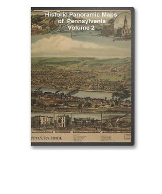
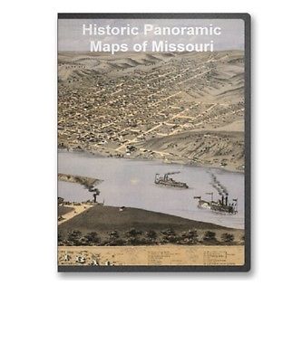
The panoramic map was a popular cartographic form used to depict U.S. and Canadian cities and towns during the late nineteenth and early twentieth centuries (1847 to 1929.) Known also as bird's-eye views, perspective maps, and aero views, panoramic maps are nonphotographic representations of cities portrayed as if viewed from above at an oblique angle. Although not generally drawn to scale, they show street patterns, individual buildings, and major landscape features in perspective.
Panoramic maps graphically depict the vibrant life of a city. Harbors are shown choked with ships, often to the extent of constituting hazards to navigation. Trains speed along railroad tracks, at times on the same roadbed with locomotives and cars headed in the opposite direction. People and horsedrawn carriages fill the streets, and smoke belches from the stacks of industrial plants. Urban and industrial development in post-Civil War America is vividly portrayed in the maps.
Victorian America's panoramic maps are quite remarkable in the perspective of the cities they capture. Most panoramic maps were published independently, not as plates in an atlas or in a descriptive geographical book. Preparation and sale of nineteenth-century panoramas were motivated by civic pride and the desire of the city fathers to encourage commercial growth. Many views were prepared for and endorsed by chambers of commerce and other civic organizations and were used as advertisements of a city's commercial and residential potential. These maps reveal much about the great contrasts and contradictions of the industrial age and the progressive era.
Preparation of panoramic maps involved a vast amount of painstakingly detailed labor. For each project a frame or projection was developed, showing in perspective the pattern of streets. The artist then walked in the street, sketching buildings, trees, and other features to present a complete and accurate landscape as though seen from an elevation of 2,000 to 3,000 feet.
Panoramic maps graphically depict the vibrant life of a city. Harbors are shown choked with ships, often to the extent of constituting hazards to navigation. Trains speed along railroad tracks, at times on the same roadbed with locomotives and cars headed in the opposite direction. People and horsedrawn carriages fill the streets, and smoke belches from the stacks of industrial plants. Urban and industrial development in post-Civil War America is vividly portrayed in the maps.
Here is a complete list of the city maps included in this collection. Where you see a city listed several times, there are several different maps - either maps created in different years and/or by different map making companies.
1. Aurora 1891Each map image on this CD is a super high resolution scan of an original panoramic map. Original maps were often as large as 36" x 36" or even larger. To offer all these maps at 100% detail, they are stored in either MRSid format or in JPEG 2000 format and require special viewers to be able to view all the details in these superb historical maps. Viewers and full viewing instructions for Windows computer platforms are included on this CD.
Some Additional Map Samples
Below you will find an example of the enlargement ability of the maps contained on this CD. You will see how you can view a small snapshot of the image all the way up to an incredible level of detail at the highest resolutions. The below set of images comes from Mystic CT and gives an excellent example of the level of detail in these maps at various levels of "magnification".
(Smallest size of this image)
(Small portion enlarged 2 times)
(Small portion enlarged 3 times)
(Small portion enlarged 4 times)
(Small portion enlarged 5 times - this enlargement represents the full
original size of the map when printed at full scale.)
As you can see from the above images, each map offers hours of exploration and excitement as you explore the cities as they were 100 or more years ago.
These maps may be viewed on your computer or printed out. The software will allow you to size the maps to any level of detail you wish and either print out the entire map or just a portion of it. (Even full scale maps can be printed with a large enough printer - like the ones used in your neighborhood poster and print shops.)
To use this software, you must install the free Map Viewing software which is included on the CD. This is a 30 second process and will allow you to view and manipulate/print all the maps in this CD collection in full detail. There are versions for both Windows platforms and full installation instructions are included on the CD.
Please visit Our About Me Page to Learn More about Us!
This product is a CD.
All our CDs are professionally produced and packaged in DVD sized cases. This allows you to easily store them with your on your shelf and retrieve them easily. Some of our CDs require a special viewer to be installed on your computer to view the images.
View Our Other Products: To view a listing of all our hundreds of products currently available, click the link below:
View All Products<--
(Note: This will open a new browser window. )
Our payment processor is PayPal
All items are covered by a 30 day money back guarantee. Only the purchase price is refunded. Shipping is not refunded. Item must be sent back at buyer's expense and buyer must include the auction ID and method of payment with the item to receive a refund.
xygooberpie123
Feedback: We give positive feedback to all our paying customers at the time your product is shipped. To purchase your CD for immediate delivery,
just click on the Buy It Now button at the bottom of the page.
|
|
|